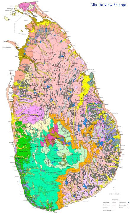
Based on elevation and nature of the terrain five geomorphic regions can be identified: the coastal fringe, the central highlands, the south-west country, the east and southeast, and the north central lowlands.
The central massif from which headwaters of all Sri Lanka's major rivers originates, is a compact physiographic unit bounded on the south by a high mountain, the Worlds End. The topography of the southwest; the other part of Sri Lanka's Wet Zone is characterized by long parallel ridges cut by the rivers beginning in the hill country. The eastern and south eastern lowlands are characterized by rolling hills, undulating plains and isolated residual hills. The coastal fringe has important fisheries and the region contains large parks and wildlife refuges that are home for wild elephants. The north central lowlands are somewhat similar to those in the east. In this region, the country's hydraulic civilization flourished.
| EXTENTS OF DIFFERENT SOIL MAPPING UNITS AND MAJOR SOIL GROUPS OF SRI LANKA | |||
| SOIL MAPPING UNITS | EXTENT OF SOIL MAPPING UNITS (Ha.) | EXTENT OF MAJOR SOIL GROUPS (Ha.) | |
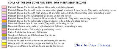
| 1 | Reddish Brown Earths & Low Humic Gley soils; undulating terrain | 1800129 | |
| 2 | Reddish Brown Earths with moderate amount of gravel in subsoil & Low Humic Gley soils; undulating terrain | 55034 | |
| 3 | Reddish Brown Earths with high amount of gravel in subsoil & Low Humic Gley soils; undulating terrain | 89648 | |
| 4 | Reddish Brown Earths & Solodized Solonetz; undulating terrain | 177456 | |
| 5 | Reddish Brown Earths, Noncalcic Brown soils & Low Humic Gley soils; undulating terrain | 247938 | |
| 6 | Reddish Brown Earths & Immature Brown Looms; rolling, hilly and steep terrain | 313500 | 2683705 |
| 7 | Noncalcic Brown soils & Low Humic Gley soils; undulating terrain | 67507 | |
| 8 | Noncalcic Brown soils, soils on old alluvium & Solonetz; undulating terrain | 65281 | 132788 |
| 9 | Red-Yellow Latosols; flat to slightly undulating terrain | 263380 | 263380 |
| 10 | Calcic Red-Yellow Latosols, flat terrain | 35152 | 35152 |
| 11 | Solodized Solonetz and Solonchaks; flat terrain | 149963 | 149963 |
| 12 | Grumusols; flat terrain | 14094 | 14094 |
| 13 | Soils on Recent marine calcareous sediments; flat terrain | 26675 | 26675 |
| 14 | Alluvial soils of variable drainage and texture; flat terrain | 501978 | 501978 |
| 15 | Regosols on Recent beach and dune sands; flat terrain | 153249 | 153249 |
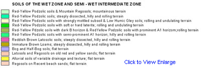
| 16 | Red-Yellow Podzolic soils & Mountain Regosols; mountainous terrain | 261737 | |
| 17 | Red-Yellow Podzolic soils; steeply dissected, hilly and rolling terrain | 821754 | |
| 18 | Red-Yellow Podzolic soils with strongly mottled subsoil & Low Humic Gley soils; rolling and undulating terrain | 157265 | |
| 19 | Red-Yellow Podzolic soils with soft or hard laterite; rolling and undulating terrain | 247037 | |
| 20 | Red-Yellow Pdzolic soils with dark B horizon & RedYellow Podzolic soils with prominent A1 horizom;rolling terrain | 12901 | |
| 21 | Red-Yellow Podzolic soils with semi-prominent A1 horizon; hilly and rolling terrain | 25212 | 1525906 |
| 22 | Reddish Brown Latosolic soils; steeply dissected, hilly and rolling terrain | 62326 | 62326 |
| 23 | Immature Brown Loams; steeply dissected, hilly and rolling terrain | 54088 | 54088 |
| 24 | Bog and Half-Bog soils; flat terrain | 57423 | 57423 |
| 25 | Latosols and Regosols on old red and yellow sands; flat terrain | 54607 | 54607 |
| 26 | Alluvial soils of variable drainage and texture; flat terrain | 51892 | 51892 |
| 27 | Regosols on Recent beach sands; flat terrain | 7852 | 7852 |